Geocodes - Add Mapping Info to an Address List for Free - Census Bureau
The U.S. Census Bureau has a free online app, Census Geocoder, that allows users to add mapping information to a list of up to 10,000 addresses at a time.  The Census Bureau describes the app as “an address look-up tool that converts your address to an approximate coordinate (longitude/latitude) and returns information about the address range that includes the address and the census geography the address is within.”
The amount of time to process a list will vary depending upon the amount of addresses in the input file and how much total demand there is on the server. It took me about 25 minutes to process a batch of 10,000 addresses at 1:00 PM Pacific on a normal workday.
Input
- File Format: Comma delimited (CSV) - Do not include a header row with field names; only include rows with address information. - Use double quotes around address values
Columns: - Unique ID (numeric; you assign) - House Number and Street Name - City - State - ZIP Code
Example: 1048,“11238 PESEO CRESTA AVE”,“LAS VEGAS”,“NV”,“89117” 1049,“12308 S PIMERA ALTA ST”,“LAS VEGAS”,“NV”,“89178” 1050,“10123 PINNACLE VIEW PL”,“LAS VEGAS”,“NV”,“89134”
The ‘City’ and ‘State’ fields may be left blank -OR- the ‘ZIP Code’ field may be left blank. But there must be the appropriate number of commas, four, in the appropriate positions to account for missing values.  Open a web browser and go to https://geocoding.geo.census.gov/geocoder/geographies/addressbatch?form
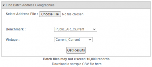
- Hit the ‘Choose File’ button and select your input file. - Leave ‘Benchmark’ and ‘Vintage’ at default values. - Hit the ‘Get Results’ button. - Wait (it could take several minutes) When the process has completed an output file will be pushed to your default downloads folder.
Output
File Format: Comma delimited (CSV)
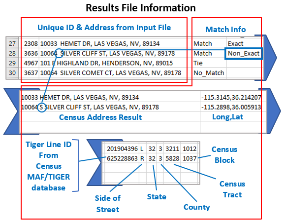
Columns: - Record ID Number - ID from input file - Input Address - Address from input file - TIGER Address Range Match Indicator - Result was matched, tied, or no match found - TIGER Match Type - Exact or non-exact - TIGER Output Address - Census address that was matched to input file address - Interpolated Longitude, Latitude - longitude and latitude estimate - TIGER Line ID - Unique ID for the edge the address falls on in the MAF/TIGER database - TIGER Line ID Side - Side of the street (L or R) - State Code - State FIPS Code - County Code - County FIPS Code - Tract Code - Census Tract Code - Block Code - Census Block Code